

There are many natural wonders on Earth, and one of them is the Nile River, the world’s longest river. The Nile River is mainly located in Egypt, but it also flows or passes through different countries in North and East Africa, like Sudan, Ethiopia, South Sudan, and Uganda.
During the time of the Ancient Egyptians, the Nile River became one of their sources of food and water. How was the Nile River instrumental in the prosperity of the Ancient Egyptians? And what is its state in the modern era? To know more, let us take a closer look at the history, uses, and other details of the amazing Nile River.
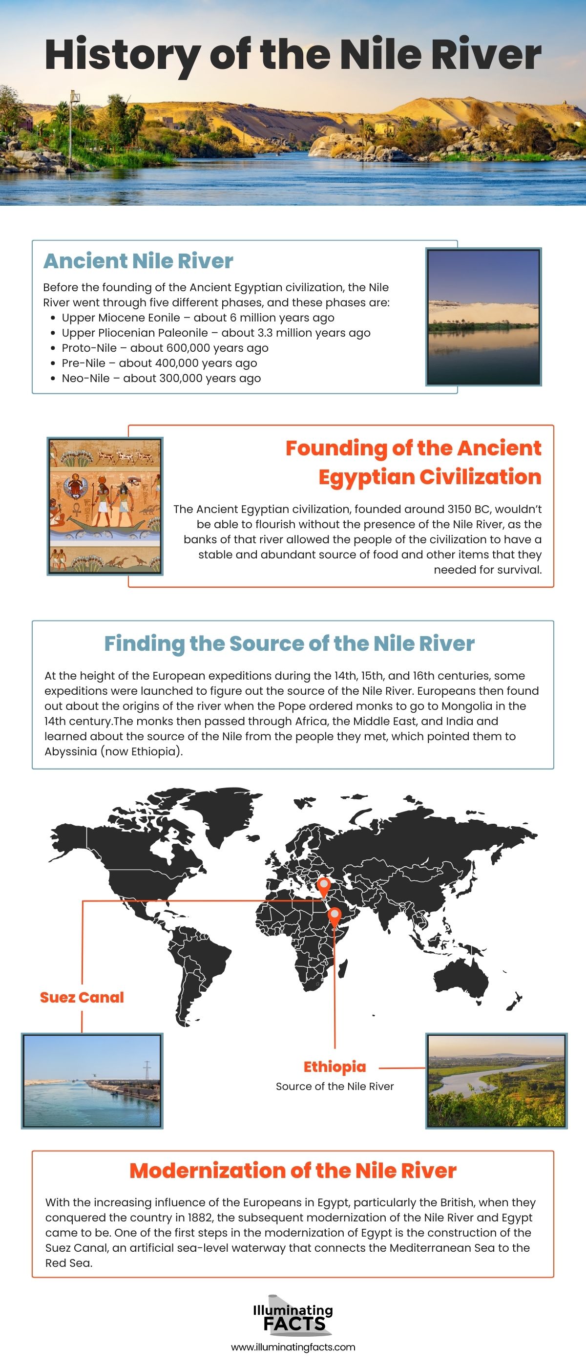
History of the Nile River

The name of the Nile River originated from the Greek word “Neilos,” which means “river valley” or simply “river.” However, during the time of the Ancient Egyptians, they called the river “Ar” or “Aur,” a term that means “black” in their language. The Egyptian name is supposed to allude to the color of the sediments found in the river whenever it is flooding. There is another name for the Nile River, “Kem” or “Kemi,” which means “darkness,” and this is regarded as the oldest name for the river. [1]
Connected to the Nile River is the Nile Delta, which is located to the north of the river and Egypt. The Nile Delta is a collection of rivers that serve as the focal point in the prosperity of the Ancient Egyptian civilization, as it is through the basin where they get the natural resources they need to survive. Historians have stated that the Ancient Egyptian civilization has thrived in the Nile River since the Stone Age.
There are three major tributaries to the Nile River, and these tributaries are separate rivers that are connected to the main river. The main tributaries are the White Nile, the Blue Nile, and the Atbara, also known as the Red Nile. Later, we will further discuss the three tributaries, but it is just important to note right now that the White Nile is located to the south and ends at Lake Victoria, the Atbara is located to the southeast, and the Blue Nile is located just below Atbara and ends at Lake Tana.
Ancient Nile River
Before the founding of the Ancient Egyptian civilization, the Nile River went through five different phases, and these phases are:
- Upper Miocene Eonile – about 6 million years ago
- Upper Pliocenian Paleonile – about 3.3 million years ago
- Proto-Nile – about 600,000 years ago
- Pre-Nile – about 400,000 years ago
- Neo-Nile – about 300,000 years ago
There was also once a canyon near the Nile River, although it is not covered and filled by surface drift, and this canyon was the Eonile, which flowed from the west of the Nile River up to the south near the end of the river. The Eonile canyon is believed to have been present from 23 million years to 5.3 million years ago. [2]
When the late-Miocene Messinian salinity crisis occurred (approximately 5.3 million years ago), the Mediterranean Sea, which is connected to the Nile River, became a closed basin. A closed basin, also known as an endorheic basin, is a type of drainage basin that doesn’t have outflow to other external bodies of water like oceans and rivers.
With the Mediterranean Sea being a closed basin during the said Messinian salinity crisis, the water of the basin evaporated and was almost empty. Because the Nile River is connected to the Mediterranean Sea, the river flows several hundred meters below the world’s ocean level.
The shrinking of the Nile River formed a deep canyon, and that canyon’s sediments redirected the south end of the Nile Delta into a depression that would eventually become Lake Moeris. In addition to Lake Moeris, another lake called Lake Tanganyika was connected to the Nile River to the far south, but the eruption of the Virunga Mountains (located in Rwanda, a country to the west of the White Nile) blocked the Nile River’s connected to the said lake. [3]
Founding of the Ancient Egyptian Civilization

The Ancient Egyptian civilization wouldn’t be able to flourish without the presence of the Nile River, as the banks of that river allowed the people of the civilization to have a stable and abundant source of food and other items that they needed for survival. With the natural resources provided by the Nile River, the Ancient Egyptians were able to cultivate different types of crops, like papyrus, wheat, and flax. Then, those crops would be used by the Ancient Egyptians as trade items to nearby civilizations and tribes, specifically those in the Middle East, which were suffering from famine during that time.
As to how the Ancient Egyptians were able to trade for items, they used boats that were capable of sailing on the Nile River. With the trading and agriculture industry of ancient Egypt prospering, the civilization quickly became one of the biggest and wealthiest among the civilizations present in Africa and the Middle East during that period.
Some of the animals that the Egyptians got from trading or simply through the visitation of people from other civilizations are the water buffalo from Asia and the camels from the Assyrians. Because of how essential the Nile River was for the Ancient Egyptians, even their calendar is based on the Nile’s three cycles, and these are:
- Akhet – the time of the year when the Nile River is flooded. The flood would then leave fertile soil.
- Peret – growing season for the crops.
- Shemu – the season where there is no rain and is a good time to harvest the crops. [4]
Finding the Source of the Nile River

At the height of the European expeditions during the 14th, 15th, and 16th centuries, some expeditions were launched to figure out the source of the Nile River. Europeans then found out about the origins of the river when the Pope ordered monks to go to Mongolia in the 14th century. The monks then passed through Africa, the Middle East, and India and learned about the source of the Nile from the people they met, which pointed them to Abyssinia (now Ethiopia).
By the 15th century, explorers were able to reach Abyssinia and went to Lake Tana, which is the source of the Blue Nile. Historians have suggested that a Jesuit named Pedro Páez was the first person to visit the source of the Blue Nile, and Páez was also able to write a very detailed account of his visit to Ethiopia and the southern portion of the Nile River. However, for many years, James Bruce, a Scottish traveler, was considered the first to find the Blue Nile’s source. [5]
In the late 15th century, some Europeans became residents of Ethiopia, and a few would have set foot in the said area before Páez, although they didn’t write anything about their life there, and if they had, the written records are gone, or are yet to be found.
As opposed to the Blue Nile, which was heavily documented by the Europeans, the White Nile was yet to be explored fully during that period. The exploration of the Nile Delta to the north began during the Turco-Egyptian Conquest of Sudan from 1820 to 1824 by Muhammad Ali, the Ottoman viceroy of Egypt who is regarded as the founder of modern Egypt.
Then, the southern portion of the White Nile, Lake Victoria, was first discovered by John Hanning Speke, an English explorer who traveled to central portion of Africa to try and discover the rumored great lakes of the area. Speke believed that the great lake, Lake Victoria, was the source of the water in the Nile River, and upon discovering it, he named it “Lake Victoria” in honor of Queen Victoria. [6]
Modernization of the Nile River

With the increasing influence of the Europeans in Egypt, particularly the British, when they conquered the country in 1882, the subsequent modernization of the Nile River and Egypt came to be. One of the first steps in the modernization of Egypt is the construction of the Suez Canal, an artificial sea-level waterway that connects the Mediterranean Sea to the Red Sea.
The construction of the Suez Canal allowed the British to move in more river steamers or boats. The river steamers were then used for tourism, as they would carry tourists from Britain to Egypt to see the pyramids and the Ancient Egyptian city of Thebes, which is found in the modern city of Luxor to the south of the Nile River.
When the Aswan Dam was constructed in 1970, it prevented the Nile River from experiencing heavy summer floods, and because the floods were important in the agriculture industry of Egypt, eradicating those floods completely changed the livelihood of the residents near the Nile River, especially the farmers. [7] Nonetheless, there are still some areas near the Nile River where irrigation and farming are possible, although the farmlands are not as abundant as before.
Major Cities Along the Nile River
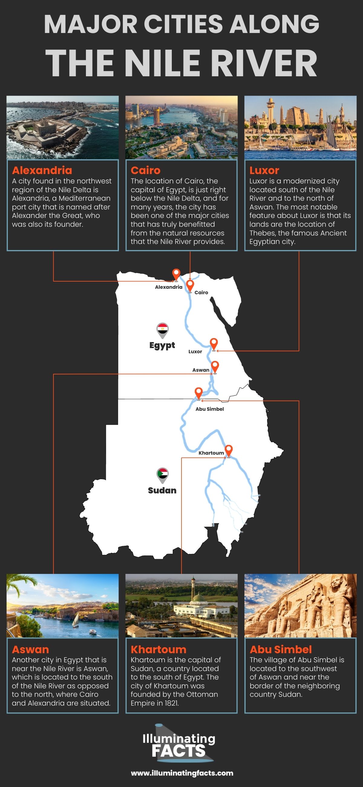
The Nile River has major cities in Egypt and Sudan that surround it, although most of the cities are primarily found in Egypt. Most of these cities rely on the Nile River for transportation and tourism, so it could be said that they would struggle to prosper if the Nile River was not cared for. Here are details about the major cities found along the Nile River.
Cairo

The location of Cairo, the capital of Egypt, is just right below the Nile Delta, and for many years, the city has been one of the major cities that has truly benefitted from the natural resources that the Nile River provides. You can see how influential the Nile River is to Cairo just by looking at the sheer size of the city, as it is not only the largest city in the Arab world, but it is also the 2nd largest urban agglomeration in Africa and the sixth-largest in the world in terms of population.
Cairo is the location for many museums that showcase the amazing history and culture of Egypt, particularly of the Ancient Egyptian civilization. The museums that tourists should visit are the Egyptian Museum that is home to artifacts from various Egyptian dynasties, and the Grand Egyptian Museum that also has various well-preserved items from ancient times. [8]
Alexandria

A city found in the northwest region of the Nile Delta is Alexandria, a Mediterranean port city that is named after Alexander the Great, who was also its founder. Alexander the Great is considered to be one of the most successful kings in history, as he was able to conquer massive lands from Western Asia and Egypt and create one of the biggest empires in history, which stretched from Greece (his homeland) to the northwestern portion of India.
The ancient city of Alexandria was founded in 331 BCE and once became a major city of the Hellenic civilization, also known as Ancient Greece. One of the Seven Wonders of the Ancient World, the Lighthouse of Alexandria, was built in the city. Unfortunately, the lighthouse was damaged by three earthquakes that occurred between 956 CE and 1323 CE, leaving only ruins on the location of the lighthouse. [9] Today, Alexandria is a popular destination for people that are interested in the history of Ancient Greece and Ancient Egypt.
Aswan

Another city in Egypt that is near the Nile River is Aswan, which is located to the south of the Nile River as opposed to the north, where Cairo and Alexandria are situated. This city in Southern Egypt is near the Aswan Dam, the world’s biggest embankment dam that is built to control the flooding in the Nile River as well as to store water for irrigation and hydroelectricity generation. [7]
Aswan is known by tourists and locals to be a busy market center where you can buy food, souvenirs, and more. The city of Aswan has expanded over the years, and through this expansion, they have absorbed Elephantine, an island within the Nile River that was a separate community before. The said island was listed on the UNESCO World Heritage List in 1979 and is home to the Aswan Museum, wherein people will be able to see various artifacts of Ancient Egypt.
Luxor

Luxor is a modernized city located south of the Nile River and to the north of Aswan. The most notable feature about Luxor is that its lands are the location of Thebes, the famous Ancient Egyptian city. Because Thebes is found within Luxor, the modern city is often regarded as the world’s best open-air museum since you can freely check out the ruins of Ancient Egypt, particularly the Karnak Temple Complex and the Theban Necropolis, where you will see the Valley of the Kings and Valley of the Queens, the site where some of the tombs of pharaohs were excavated. [10]
Tourism is arguably Luxor’s biggest source of income, and it is thanks to the thousands of tourists that visit the beautiful city each year that Luxor has become a highly modernized city compared to some of the cities in Egypt. However, despite being modern, the government of Luxor has done its best to preserve the ancient ruins and temples within the city.
Abu Simbel

Although Abu Simbel is a village and not a city, it is considered to be a very important place in Egypt, as it is where you will find the Nubian Monuments, a heritage site where you will find the Temple of Amada, the oldest Egyptian Temple in the region of Nubia (where Abu Simbel is), as well as the Valley of the Lions, which houses Ancient Egyptian temples that were constructed in the 13th century BCE, particularly during the reign of a pharaoh named Ramesses II in the 19th Dynasty. [11]
The village of Abu Simbel is located to the southwest of Aswan and near the border of the neighboring country Sudan. Interestingly, Abu Simbel has a regional airport aptly named Abu Simbel Airport, and it caters to the EgyptAir airline that flies to Aswan and Cairo.
Khartoum

Khartoum is the capital of Sudan, a country located to the south of Egypt. The city of Khartoum was founded by the Ottoman Empire in 1821. When the United Kingdom gained major power in Egypt, they left the administration of the areas of Sudan to the Egyptian government until 1884, when the Mahdist forces, which believed in a messianic figure, the Mahdi, who would eradicate evil and injustice when he appears during the end of times. [12] The leader of the forces during that time, Muhammad Ahmad, claimed to be the Mahdi.
The Mahdist forces then took control of Sudan in 1884. However, Khartoum and Sudan would later be reoccupied by the British in 1898 and would remain in power until 1956, when Sudan was declared to be an independent country and declared Khartoum to be the country’s capital. In Khartoum, people can find various museums that showcase Sudan’s history and culture. These museums include the National Museum of Sudan and the Khalifa House Museum.
Stats About the Nile River

There are so many amazing features and functions of the Nile River, and it is not only interesting because of its vast history. The Nile River is one of the most important natural creations in Africa, and without it, most of the continent wouldn’t be able to have civilizations and societies. Despite the popularity of the Nile River, there are only a few people that know about its length, where its origins, the countries it flows through, and other simple facts. To know more, here are some stats about the Nile River. [13]
Length: 4,160 miles (6,695 kilometers)
Location: East of Africa
Source of the River: Lake Victoria (White Nile) and Lake Tana (Blue Nile)
Main Tributaries: White Nile, Blue Nile, and Atbara (Red Nile)
Countries near the River: Uganda, Rwanda, Burundi, Ethiopia, Kenya, South Sudan, Sudan, and Egypt
Mouth of the River: Northern Egypt, from the Nile Delta to the Mediterranean Sea
Most people would say that the source of the river is the Mediterranean Sea, but that is actually not the case, as the Nile River actually flows from the south to the north. So, from Burundi, a country in East Africa, the Nile River would travel northward towards Egypt, the Nile Delta, and the Mediterranean Sea. So, the water first flows through the White Nile and travels north. However, there is also the Blue Nile that gives water to the Nile River as well, and the Blue Nile originates at Lake Tana.
While Lake Victoria and the White Nile are considered by many to be the main source of water for the Nile River, studies have shown that it is actually Lake Tana and the Blue Nile that are responsible for bringing 80% of water into the main river. The White Nile flows through Uganda and South Sudan, and then the Blue Nile flows through Uganda. These two main tributaries would then connect or meet at Khartoum, the capital of Sudan.
There is another main tributary to the Nile River called the Atbara, also known by some as the Red Nile. The Red Nile is located just north of the Blue Nile and is also located in Ethiopia. The Red Nile is approximately 500 miles (800 kilometers) long, and while it is the main tributary, it doesn’t provide water to the Nile River during the dry season (January to June), as it dries up quickly in that period.
The Uses of the Nile River in Modern Times

Even though Egypt and the other countries that benefit from the Nile River have been modernized, they are still using the Nile River for various purposes or functions. Take a look below for pieces of information about the uses of the Nile River in Modern Times.
Irrigation

Because most of the lands in the northern section of Africa are dry, the people there would have to find ways to get water to those dry lands in order to make them fertile. One of the best ways for these people to do so is by irrigation, which is a system that enables water to be transported from a major source (in this case, the Nile River) to dry farmlands.
In the areas near the Nile River, there are irrigation techniques that are used, and these are flood irrigation, lift irrigation, and canal irrigation. [14]
Flood Irrigation
Flood irrigation is a technique wherein the Nile River or its tributaries will flood the banks while also carrying silt, a fine material that is essential for creating fertile soil. After the flood subsides, some water and silt would remain in the banks, which would then create fertile soil suitable for farming. However, because the flooding only happens on the banks near the Nile River once a year, and sometimes the flood may not even come at all, flood irrigation is not used as frequently as the other two techniques.
Lift Irrigation
The lift irrigation technique involves lifting water from the river and then transferring it to the dry farmlands. There are many ways to lift the water, and some of the most popular methods are the water wheel, the Archimedes screw, and the diesel or electric pump, the water wheel rotates a chain of buckets that is constantly filled with water by the river, and a person can then take a bucket and carry it to the farmlands.
The Archimedes screw has a large tube that has an upward spiral contraption inside that carries the water from the bottom to the top while the tube is being turned repeatedly. Then, the most common lift irrigation method, the diesel or electric pump, has an automatic pump that collects water from the river and pumps it out to the farmlands.
Canal Irrigation
The last irrigation technique is canal irrigation, wherein various dams are built within the Nile River to control the flow of water, and then the built canals are connected to those dams in order to transfer water to farmlands. Canal irrigation is the most modern irrigation technique and is not the most widely used in the areas near the Nile River.
Transportation

Transportation is another use of the Nile River, as some people in countries where the river flows would sail or ride on small boats in order to get from one city or town to another. The boats that people use on the Nile River are called “felucca,” which is a small river vessel that has a large triangular sail. [15]
But, the number of people that use the Nile River for transportation is decreasing over the years, as faster modes of transportation like trains and airplanes are becoming more common in Egypt and other countries near the Nile River. On the other hand, those faster modes of transportation can sometimes be more expensive than boat rides, which is why boats on the Nile River are still present despite the modernization of Northern and Eastern Africa.
Hydroelectricity

The people in Egypt and other countries near the Nile River are getting abundant amounts of electricity thanks to the hydropower dams located in different sections or areas of the river. A few of these hydropower dams include the Bujagali Hydroelectric Power Station near Lake Victoria, the Kiira Hydroelectric Power Station in Uganda, and the Nalubaale Hydroelectric Power Station across the White Nile. There is also a hydroelectric plant in the Aswan Dam in Aswan, Egypt.
Tourism

One of the most profitable uses of the Nile River today is tourism, as millions of tourists visit the Nile River and its surrounding countries every year. Besides transportation, the small boats in the Nile River are also used for tourism since these boats are the only way that tourists can truly see the beauty of the river.
Tourism in the Nile River has also given some people business opportunities, like setting up boat rental services for tourists, as well as running restaurants and food stalls near the Nile River where tourists can try out local dishes and delicacies. With tourism, the people near the Nile River would have jobs and a stable source of income. [16]
The Issues of the Nile River

The modernity of the Nile River and the growing population and economy of the countries around it have produced numerous issues that are still being resolved today. To learn more about these issues, read below to get the details for each of them.
Population Density
One of the biggest issues of the Nile River is the density of the population in the areas near it. The population density along the Nile is regarded as one of the highest in the world, as there are about 5,000 people per square mile in the lands near the river in Egypt. The population in Egypt has been increasing rapidly throughout the years, and the majority of the population in the country is just under 15 years old. To find out how young the population is in Egypt, here is a graph that shows the age breakdown in the country in 2019. [17]
Egypt Age Breakdown (in 2019) |
|
| Age Range | Percentage |
| Under 15 Years Old | 34.2 |
| 15-29 Years Old | 26.8 |
| 30-44 Years Old | 20.0 |
| 45-59 Years Old | 12.3 |
| 60-74 Years Old | 5.7 |
| Over 75 Years Old | 1.0 |
In order to decrease the speed or lower the birth rate of the rapidly growing population in Egypt, the country’s government created a family planning program in 1964, and it has been successful in controlling the population density in various areas, including the ones located near the Nile River.
Pollution
Pollution is also another big problem in the Nile River, as about 97% percent of the waters in the river are contaminated with wastewater and other kinds of pollutants. Most of the wastes within the Nile River are caused by industrial and municipal establishments near the river, which often release hazardous chemical and industrial waste to the river. [18]
A significant percentage of the wastewater remains untreated, and then it will start contaminating the waters that will be utilized for irrigation and farming. So, the quality of the water used for farming would suffer, and the crops may not grow properly. Fortunately, the Egyptian government is doing its best to fix the pollution issues of the Nile River by applying stricter laws or rules about waste disposal while also improving the water treatment systems in the dams built on the river.
Water Disputes
The issue in the Nile River that should be fixed as soon as possible is the water dispute that involves Egypt, Sudan, and Ethiopia. Although the dispute was temporarily solved during the 1959 watercourse treaty, wherein Egypt received 55.5 billion cubic meters annual share of the Nile River while Sudan got 18.5 billion cubic meters, the dispute for the Nile River started again in 2011 when Ethiopia, another country that benefits from the Nile River, started a project called the Grand Ethiopian Renaissance Dam. [19]
The Grand Ethiopian Renaissance Dam, also known simply by its acronym GERD, would allow Ethiopia to have better control of the waters in Lake Tana and the Blue Nile, the biggest contributor to the headwaters of the Nile River. According to studies, the GERD would allow Ethiopia to store about 74 billion cubic meters of water in its reservoir, which is huge compared to the annual share of Egypt in the river.
Because of how much water the GERD can collect, Egypt and Sudan are now in fear of suffering from water shortage since the dam can reduce the waters of the main Nile River. [20] The Grand Ethiopian Renaissance Dam was opened on July 21, 2020, and as of 2022, Egypt, Sudan, and Ethiopia are still discussing how to solve the dispute so that they can have a fair share of the Nile River.
Interesting Facts about the Nile River
- During the time of the Ancient Egyptians and the period when there were no dams built yet, the Nile River would often produce a massive flood every August.
- With the construction of the Aswan Dam in 1970, the yearly flooding in the Nile River no longer happens. In order for the people near the river to have fertile soil for farming, they would have to rely on irrigation systems. [21]
- The Nile River is home to different species of birds, snakes, and turtles, but the most famous animal found on the river is the Nile crocodile, one of the world’s largest reptiles.
- Although the Nile River is considered the longest river on Earth, many researchers have said that the Amazon River is possibly longer. However, the current calculation for the length of the Amazon River is 4000 miles or 6,500 kilometers, while the Nile River is 4,160 miles or 6,695 kilometers.
- There is a peculiar bend or curve that happens to the south of the Nile River and just north of where the Blue Nile and the White Nile connect. This curve is known as the “Great Bend,” which is caused by an underground rock formation called the Nubian Swell that forced the flow of the Nile River to curve. [22]
- The most well-known plant found in the Nile River is the papyrus, a flowering sedge that grows in shallow water. Papyrus was used by the Egyptians to make paper, and the term “paper” actually came from the papyrus. Unfortunately, papyrus is not as common anymore in the Nile River compared to its abundance in the past.
- The Nile River is responsible for about 10% of Africa’s water supply, although it is still Egypt that primarily benefits from the Nile River’s waters.
- In the time of the Ancient Egyptians, they worshipped a god named Hapi in order to bring the flood from the Nile River into the farmlands to produce fertile soil. As such, Hapi is regarded as the Egyptian god of the flood. [23]
- Historians believed that the Nile River was instrumental in the construction of the pyramids in Egypt. The rocks and blocks of stones used to make the pyramids are said to have been transferred from one location to another easily by using boats that traverse the Nile River.
- The granite blocks that were used to construct the interior and the center of the pyramids mostly came from Aswan, which is relatively close to the Nile River.
- Besides the papyrus, the other species of plants found in the Nile River are bamboos, banana trees, ebonies, and water hyacinths.
- The crocodiles in the Nile River are often praised and honored, as some people in Egypt believe that the crocodiles are the earthly manifestation of gods. Some crocodiles would even be adorned with jewelry to further emphasize how much the people revere the reptiles. [24]
- The popular Egyptian cotton is grown on fertile soil that relies on the waters of the Nile River. Besides cotton, there are also other crops like wheat that are grown on the farmlands near the river.
- There was once another tributary to the Nile River called the Yellow Nile, which is found to the north of the Blue Nile. However, instead of flowing from the east to the west like the Blue Nile and Atbara, the Yellow Nile flowed from the east to the west and started in the country of Chad. However, the Yellow Nile dried up in 1000 BCE.
- The Ancient Egyptians believed that the west side of the Nile was the place of death, while the east side was the place of life. So, the tombs and pyramids where pharaohs and other important people in Ancient Egypt were built on the west side of the Nile.
References
[1] El-Kammash, M. Nile River – river, Africa. Encyclopedia Britannica. Retrieved September 9, 2022, from https://www.britannica.com/place/Nile-River
[2] Duff, R.J. (2019, May 31). The Lost Grand Canyon of Egypt, Part II: Origins of the Nile River Valley. Naturalis Historia. Retrieved September 9, 2022, from https://thenaturalhistorian.com/2019/05/31/the-lost-grand-canyon-of-egypt-part-ii-origins-of-the-nile-river-valley/
[3] Ondaatje, C. (2016, July 13). The unsettling sources of the Nile. Geographical Magazine. Retrieved September 9, 2022, from https://geographical.co.uk/science-environment/the-unsettling-sources-of-the-nile
[4] Dresser S. and Muscato, C. Egypt’s Seasons: Akhet, Peret & Shemu. Study.com. Retrieved September 9, 2022, from https://study.com/learn/lesson/egypts-seasons-akhet-peret-shemu.html
[5] The Editors of Encyclopedia Britannica. Pedro Páez – Spanish priest. Encyclopedia Britannica. Retrieved September 9, 2022, from https://www.britannica.com/biography/Pedro-Páez
[6] The Editors of Encyclopedia Britannica. John Hanning Speke – British explorer. Encyclopedia Britannica. Retrieved September 9, 2022, from https://www.britannica.com/biography/John-Hanning-Speke
[7] The Editors of Encyclopedia Britannica. Aswan – dam, Egypt. Encyclopedia Britannica. Retrieved September 9, 2022, from https://www.britannica.com/topic/Aswan-High-Dam
[8] ETP Team. (2017, November 18). Cairo City. Egypt Tours Portal. Retrieved September 10, 2022, from https://www.egypttoursportal.com/cairo-city/
[9] Cartwright, M. (2018, July 24). Lighthouse of Alexandria. World History Encyclopedia. Retrieved September 10, 2022, from https://www.worldhistory.org/Lighthouse_of_Alexandria/
[10] Handwerk, B. Valley of the Kings. National Geographic. Retrieved September 10, 2022, from https://www.nationalgeographic.com/history/article/valley-of-the-kings
[11] Elkatouri, H. Abu Simbel. African Wildlife Safaris. Retrieved September 10, 2022, from https://www.africanwildlifesafaris.com/destinations/africa/egypt/abu-simbel/
[12] Lohnes, K. Siege of Khartoum – Sudanese history. Encyclopedia Britannica. Retrieved September 10, 2022, from https://www.britannica.com/event/Siege-of-Khartoum
[13] Barrow, M. (2013). The River Nile – the longest river in the world. Primary Homework Help. Retrieved September 10, 2022, from http://www.primaryhomeworkhelp.co.uk/rivers/nile.htm
[14] Donfelix (2017). Irrigation in the Nile Valley. Steemit. Retrieved September 12, 2022, from https://steemit.com/science/@donfelix/irrigation-in-the-nile-valley
[15] Canadian Museum of History. Egyptian Civilization Daily Life – Transportation. Canadian Museum of History. Retrieved September 12, 2022, https://www.historymuseum.ca/cmc/exhibitions/civil/egypt/egcl04e.html
[16] Mugume, D. (2018, May 3). Is the Nile still an important transport route? The Niles. Retrieved September 12, 2022, from https://www.theniles.org/en/articles/economy/20627/
[17] The Editors of Encyclopedia Britannica. Egypt – Demographic trends. Encyclopedia Britannica. Retrieved September 12, 2022, from https://www.britannica.com/place/Egypt/Demographic-trends
[18] Dakkak, A. (2021, September 29). Water Crisis in Egypt and Degeneration of the Nile. EcoMENA. Retrieved September 12, 2022, from https://www.ecomena.org/egypt-nile/
[19] Polakovic, G. (2021, July 13). Water dispute on the Nile River could destabilize the region. USC News. Retrieved September 12, 2022, from https://news.usc.edu/188414/nile-river-water-dispute-filling-dam-egypt-ethiopia-usc-study/
[20] Mutahi, B. (2020, January 12). Egypt-Ethiopia row: The trouble over a giant Nile dam. BBC News. Retrieved September 12, 2022, from https://www.bbc.com/news/world-africa-50328647
[21] National Geographic Kids. Nile River Facts. National Geographic Kids. Retrieved September 12, 2022, from https://www.natgeokids.com/uk/discover/geography/physical-geography/nile-river-facts/
[22] McLendon, R. (2020, January 27). 9 Interesting Facts About the Nile River. Treehugger. Retrieved September 12, 2022, from https://www.treehugger.com/nile-river-facts-4868689
[23] Arindom. 30 Enchanting Facts About the River Nile That Will Stir Your Curiosity. Earth Eclipse. Retrieved September 12, 2022, from https://eartheclipse.com/science/geography/river-nile-facts.html
[24] Lilian. (2022, August 2). Top 15 Astonishing facts about the River Nile. Discover Walks Blog. Retrieved September 12, 2022, from https://www.discoverwalks.com/blog/egypt/top-10-astonishing-facts-about-the-river-nile/